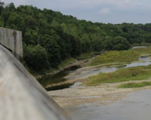
 WROXETER – Continuing dry conditions have prompted the Maitland Valley Conservation Authority to step up its notice of low water flow across its watershed from a Level 1 to a Level 2 today.
In July, a Level 1 Low Flow Bulletin was issued for the Maitland watershed. Continuing dry conditions across the watershed and declining flows in the river system have caused the local Water Response Team to upgrade the bulletin to a Level 2 Low Flow Bulletin.
Level 2 bulletins are issued when stream flows are approximately 50 per cent of their normal flow or the watershed’s precipitation for one month falls below 60 per cent of average.
The Lower Maitland River sub-basin is being particularly hard hit by low flows.
The long-term average flow at Benmiller is 9.2 cms (cubic metres per second) but during the first eight days of August the flow rate averaged 1.9 cms, according to a press release issued today.
On Aug. 8, the flow rate was just 1.49 cms.
This may have a significant impact on water quality in the area and is detrimental for aquatic species. Levels this low make it very difficult for fish to move freely and may restrict their ability to find food and shelter. Lower water levels also leads to higher water temperatures and this in turn may create algae blooms in the river.
With the implementation of the Level 2 Low Flow Bulletin, watershed residents are strongly encouraged to reduce activities that remove water directly from watercourses. In a Level 2 situation, municipalities and the provincial government may implement or increase restrictions on non-essential water use.
The Ontario Ministry of Natural Resources has developed a Low Water Response Strategy to assist areas experiencing low water conditions. Under the strategy, Water Response Teams are formed so local communities can carry out actions to reduce and better manage water use.
The Water Response Team in the Maitland watershed includes representatives from municipalities, agricultural groups, Ministries of Environment, Natural Resources and Agriculture, Food and Rural Affairs, and the MVCA.
The MVCA monitors precipitation, stream flow and water levels in order to recognize and measure the severity of low water conditions. Staff at the MVCA is working to develop a more comprehensive understanding of flow levels in dry conditions. It would like to get a more accurate picture of how landowners are using river water. For example, it would like to learn more about how much water is being used and when it’s being used.
In addition staff would like to hear how shallow wells are holding up during this dry period.
Anyone who would like to share information about low flows in their area is asked to contact Mat Shetler at [email protected] or call 519 335-3557.


